Description
🌍 Survey Smarter, Not Harder — Precision in Your Palm!
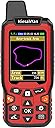
- CRYSTAL CLEAR DATA AT A GLANCE - 2.4-inch backlit LCD screen ensures effortless reading even in challenging outdoor lighting.
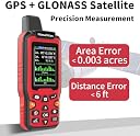
- PRECISION THAT COMMANDS CONFIDENCE - Harness dual satellite systems (GPS+GLONASS) for ultra-reliable, global land surveying accuracy.
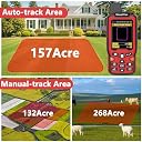
- VERSATILE 4 IN 1 MEASUREMENT MODES - Measure areas and distances—straight or curved—with professional-grade topographical mapping tools.
- POWER THROUGH YOUR LONGEST EXPEDITIONS - Up to 20 hours of battery life keeps you surveying all day without interruption.
- LIGHTWEIGHT RUGGEDNESS FOR ON THE GO PROS - Compact 180g design with ergonomic grip built to withstand rugged terrains without fatigue.
The NiesahYan ZL180 is a handheld GPS surveying tool featuring dual GPS+GLONASS satellite support for high-precision land measurement with an error margin as low as 0.003 acres. Its 2.4-inch backlit LCD display offers clear, real-time data visualization, while its lightweight, ergonomic design ensures comfort during extended use. Designed for professionals working in forests, farmland, and mountainous terrain, it supports versatile 4-in-1 measurement modes and delivers up to 20 hours of battery life for uninterrupted fieldwork.