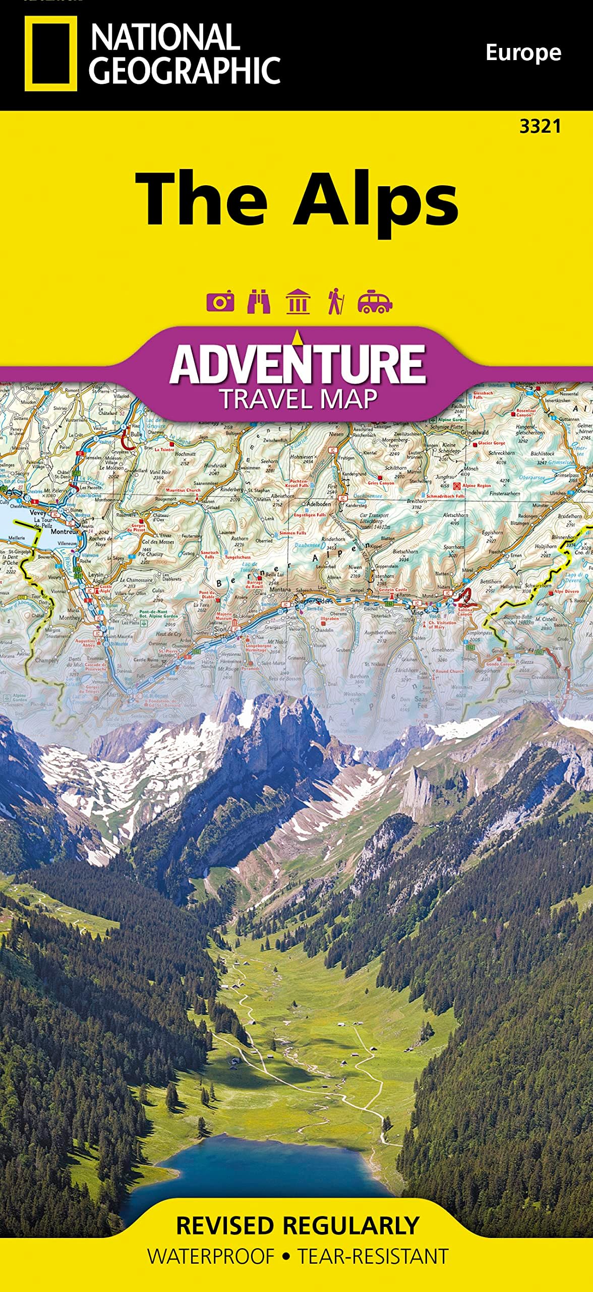
Alps Map (National Geographic Adventure Map, 3321)
Product ID: 19163267
Desertcart purchases this item on your behalf and handles shipping, customs, and support to Japan.
Alps Map (National Geographic Adventure Map, 3321) [National Geographic Maps] on desertcart.com. *FREE* shipping on qualifying offers. Alps Map (National Geographic Adventure Map, 3321) Review: Good map for planning - Nice map - bought it for planning purposes, rather than for use in actual travel. It was the only map that had Germany, Austria, Switzerland, Lichtenstein all together. You have to flip the map to see it all, but seems good for planning a trip. Waterproof and unlikely to tear after several folding and unfolding efforts. Review: Making our Bucket List ski trip to the ALPS a success. - Great maps, and very reasonable pricing and fast shipping. Accurate and easy to read. We bought two and mounted one on a poster board backing so we could hang on a wall and mark our travel routes and times. We are super pleased with the order and thankful to desertcart for adding to the success of our trip in February to the French Alps - 3 Valleys, Dolomiti Superski, Zermatt, Andermatt and Gemstock and Davos. Taking my 20 and 25 year olds Grandsons for a dream vacation of their lives. These maps are the exact perfect travel guide for us.


| Best Sellers Rank | #137,834 in Books ( See Top 100 in Books ) #167 in General Europe Travel Guides #172 in Atlases (Books) #219 in Maps (Books) |
| Customer Reviews | 4.5 4.5 out of 5 stars (81) |
| Dimensions | 4.25 x 0.2 x 9.25 inches |
| Edition | 2022nd |
| ISBN-10 | 1566956404 |
| ISBN-13 | 978-1566956406 |
| Item Weight | 3.21 ounces |
| Language | English |
| Print length | 2 pages |
| Publication date | January 1, 2022 |
| Publisher | Natl Geographic Society Maps |
K**C
Good map for planning
Nice map - bought it for planning purposes, rather than for use in actual travel. It was the only map that had Germany, Austria, Switzerland, Lichtenstein all together. You have to flip the map to see it all, but seems good for planning a trip. Waterproof and unlikely to tear after several folding and unfolding efforts.
R**H
Making our Bucket List ski trip to the ALPS a success.
Great maps, and very reasonable pricing and fast shipping. Accurate and easy to read. We bought two and mounted one on a poster board backing so we could hang on a wall and mark our travel routes and times. We are super pleased with the order and thankful to Amazon for adding to the success of our trip in February to the French Alps - 3 Valleys, Dolomiti Superski, Zermatt, Andermatt and Gemstock and Davos. Taking my 20 and 25 year olds Grandsons for a dream vacation of their lives. These maps are the exact perfect travel guide for us.
J**O
Transitting the Apls.
Great map of the roof of Europe!
C**R
but it was also fantastic for bouncing between Austria and southern Germany
This map covered all of what we needed and more. I bought it for our trip to Austria, but it was also fantastic for bouncing between Austria and southern Germany, and then later when we drove down through Slovenia into Croatia. There is no city detail, but we used the free app Maps.me to download offline maps (which was awesome in Europe) which helped us with GPS and general navigation through spots that the NatGeo map was not detailed enough in.
R**B
Great Map
Great Map very detailed.
B**N
Great for planning road trips.
This is great for planning road trips through the Alps. The material is tougher than paper and resists water well.
G**6
Nice map but
Nice map but hard to read to big of scale for route planning gives good general view of the area but hard to route plan from
J**N
Most helpful!
The map was very helpful in planning our trip to Switzerland and Italy!
S**H
I bought this as a present - It was very well packed. So far nothing bad to say about it! all good! :)
N**E
perfect for alp route planning . Details amazing too
A**A
Purtroppo la carta risulta poco dettagliata (rispetto ad altre di pari scala), mancano numerose strade secondarie e il nome di molti passi/colli alpini. Per una cartina della Alpi purtroppo questa è una grave carenza. La mappa inoltre risulta di non immediata lettura (scelta dei colori) e non sono segnalate (come per la maggior parte delle carte di altre case editrici) strade panoramiche o di interesse turistico. Eseguito il reso. Spedizione Amazon impeccabile come sempre.
M**L
The scale is too small. 1:600 000. I expected 1:24K as the Everest base camp map sold by Nathional geographic.
A**ー
チロルに行く予定で購入したが、全体像を把握するのに役立っている。
Trustpilot
1 month ago
1 month ago